 |
|||
|
|
|
||
|
|
|
||
|
This page will take longer to load than our standard
pages as it is proportionally 'graphic rich'.
|
||||
|
|||||||||||||||||||||||||||||||||||||||||||||||||
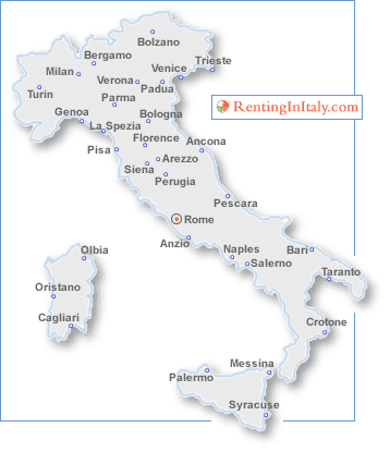 |
To give an idea of scale, here
are a few sample distances between some major Italian cities, running
broadly north to south: |
||||||||
|
Miles
|
KM's
|
||||||||
|
|
From Bolzano to Bergamo |
143
|
230
|
||||||
| From Bolzano to Trieste |
210
|
338
|
|||||||
| From Trieste to Venice |
102
|
165
|
|||||||
| From Venice to Parma |
131
|
211
|
|||||||
| From Parma to Bologna |
56
|
90
|
|||||||
| From Bologna to Florence |
66
|
106
|
|||||||
| From Florence to Pisa |
57
|
92
|
|||||||
| From Florence to Siena |
43
|
70
|
|||||||
| From Siena to Perugia |
58
|
94
|
|||||||
|
|
From Perugia to Rome |
109
|
176
|
||||||
| From Rome to Naples |
144
|
232
|
|||||||
| From Naples to Bari |
200
|
322
|
|||||||
| From Naples to Messina |
330
|
533
|
|||||||
| From Messina to Palermo |
160
|
258
|
|||||||
| Click here to view a detailed table of Italian cities and distances (in miles) between them. Click here to view the same table with distances expressed in kilometres. |
|||||||||
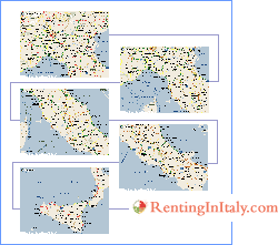 |
The map to the left shows Italy roughly split
into five sections - click on the 'bit' that interests you to see a larger
map of that area, or alternatively use the links below: |
||||||||
| Northern Italy, showing Milan, Turin, Venice, Trento, Brescia and Genoa. | |||||||||
| Northern and central Italy showing Parma, Genoa, La Spezia, Bologna, Prato. Florence and Livorno. | |||||||||
| Central Italy showing Florence, Siena, Arezzo, Ancona, Perugia, Orvieto, Pescara and Rome. | |||||||||
| Southern Italy showing Rome, Campobasso, Foggia, Naples, Salerno and Bari. | |||||||||
| Southern Italy and Sicily showing Cosenza, Catanzaro, Reggio di Calabra, Messina, Catania, Syracuse and Palermo. | |||||||||
|
|||||||||||||